POINTS OF INTEREST
 artigiani e produttori
 panorama
 cultura
 aree di sosta
CAMPODOLCINO TO SAN SISTO
From Campodolcino the route meanders along the first stretch of asphalt road which takes you to Starleggia, a small village recognised over the years for its production of delicious potatoes, still in great demand today for their wholesomeness and antioxidant properties.
Departure from Campodolcino is from the area that flanks the Liro Torrent called “Acquamerla”. It’s a park area with a playground and kiosk for refreshments. The name of the park derives from the soft-water spring (low in minerals) which rises right here and is well-known to locals for its properties. The stretch that takes you to Starleggia is characterised by a series of twists and turns within woodland. Every now and then the enduring tranquillity that only the mountains can deliver is interrupted by the roar of a nearby waterfall. At some points the eye is drawn to the slopes on the opposite side of the valley where you can admire the twisting road at Pianazzo, a feat of engineering from the early 19th century, the work of Donegani. A little further to the left you pick out the “galleries” that lead to the Passo dello Spluga and Andossi. There’s another fine vantage point on the climb on reaching the little nucleus of Splughetta, an ideal place for a well-earned break.
After passing through the village of Starleggia with its attractive stone dwellings you take on a dirt track, with gentle enough slopes, which leads into the magnificent and expansive valley of San Sisto and the village itself. To get to the top means going through fine larch woodland, which in Autumn hosts multi-hued shades ranging from gold to deep red, mixed in with browns and yellows.
Once you get to the amphitheatre of San Sisto, to the west Pizzo Quadro dominates all, whilst to the east the natural balcony opens onto upper Valle Spluga and in particular over Alpe Motta and Pizzo Groppera.
After San Sisto you can pedal onwards towards the interior valley, but only on pathways, and if you choose to you’ll first reach Alpe Cusone followed by the hamlets of Fornal and Alpe Morone. If instead you take off in a north-easterly direction you’ll come across a 17th century tower standing tall as though a silent lookout¸ used over the years for strategic and military purposes.
The route is a gentle one on the whole and suitable for family outings.
ALTIMETRY
DETAILS
 |
LENGTH | km |
 |
DURATION | h |
 |
difficulty | 2/4 |
 |
AVERAGE GRADIENT | % |
 |
PERIOD | From May to October |
 |
MOBILITY MEANS | mountain bike |
 |
bikeability | % |
 |
TERRAIN | asphalt, pathway |
 |
PANORAMA | 1/4 |
CALCOLA IL PERCORSO
CICLOTURISMO IN VALTELLINA
Percorsi ciclabili in Valchiavenna e a Madesimo
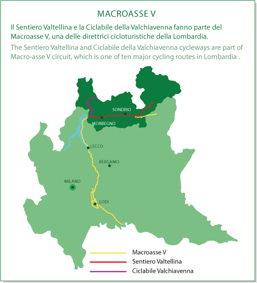
MACROASSE V